| © 2008 by SourceSink consortium - all rights reserved |
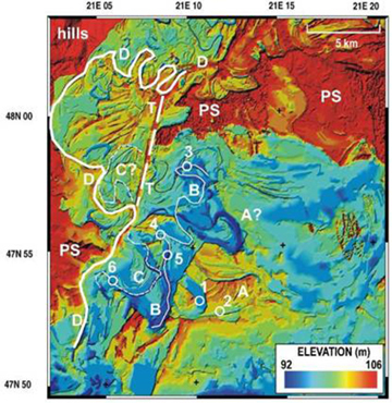 |
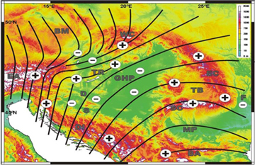
(Left) Recent evolution of the Tisza River, Great Hungarian plain. Note the changes in the meandering system and evolution of successive river terraces (Timar et al., 2005). (Right) Stress trajectories and vertiocal movements in the Carpathians – Pannonian domain (modified from Bada et al., 1999). |
Brief description (details available by contacting dr. Gabor Bada)
The principal objective of the ongoing "TECTOP-Hungary" project is the quantitative analysis of active tectonic processes in Hungary, with an outlook to its wider tectonic environment, the inverting Pannonian basin system. Mapping and quantifying the Quaternary to Recent 3D deformation pattern is carried out in the framework of a coherent, process oriented research programme that builds on an integrated and multi-scale approach, both in time and space. Research activities aim at coupling processes operating on a lithospheric scale, and the close interaction and feedback mechanisms between neotectonics and surface processes are investigated. With the aid of a great variety of observation techniques, making use of international co-operation within the Topo-Europe network, the scientific objectives are implemented in selected study areas representing the most actively deforming parts of Hungary.
Active crustal deformation and related surface processes in an active source-to-sink system has generated great scientific interest and attention in Hungary in recent years. Research activities, on national as well as international level, have led to the growing recognition of the increasing societal importance of neotectonic and related landscape-forming processes. Understanding and quantifying related natural hazards, such as earthquakes, slope instability, and flooding in the vulnerable environment of Central Europe is a serious challenge for the scientific community. Besides hazards, however, active deformation and basin inversion can for instance result in a better prospect for the petroleum industry. Geoprediction in the actively inverting Pannonian basin requires a multidisciplinary approach and, therefore, the interaction and collaboration of researchers from a significantly broader field of geo-expertise than hitherto considered. One of the main challenges is to understand the solid Earth as a dynamic system by improving the quantification of recent lithospheric deformation and the controls and feedback mechanisms of neotectonic and surface processes. Identification of areas of active subsidence in the light of flood defence strategies is of key importance. In regions of ongoing surface uplift, combined mapping of active or exposed (older) faults and areas of high topographic gradients provides input for delineating zones of increased slope instability. Active tectonic processes also strongly influence the habitat of natural resources (water and hydrocarbons). All these aspects give an essential societal context of the "TECTOP-Hungary" project, contribute to significant added value through the implementation of Topo-Europe programme.
The research programme of "TECTOP-Hungary" has been carried out using a well selected set of methodologies. The process oriented character of this research programme is essential as phenomenological observations alone, either obtained from the geological record (e.g. fault mapping) or based on historical records (e.g. seismicity), do not provide a complete assessment of active deformation processes. Research activities aim at coupling processes operating on 3D lithospheric scale with those active at or near the Earth’s surface. The close interaction and feedback mechanisms between neotectonics and surface processes is also addressed. In order to focus on specific problems and to concentrate capacities, and keeping in mind the scientific objectives and challenges, the following main methodologies are employed:
- Mapping of active structures: Methodology development and GIS based catalogue
- Controls on fault reactivation: Tectonic stability and seismotectonic habitat
- Active tectonics vs. hydrography: Tectonic controls on lake and river network development
- Temporal aspects: Reconstruction of vertical vs. horizontal strain rates
- Dynamics of basin inversion: Rheology and stress field in the Pannonian lithosphere
Work plan: The 3D pattern of active tectonic and surface processes in the central Pannonian basin are investigated in the framework of a coherent, process oriented research programme that is planned around the above described five main themes. Each of these themes, addressing different aspects of the tectonic and related surface processes, are considered vital in the analysis of active deformation. Research efforts within these topics are made in a carefully planned time sequence, i.e. related deliverables provide input for parallel and/or subsequent scientific activities. The duration of the project is 3 years, running through spring 2006 to spring 2009.
Deliverables and/or milestones: In the framework of "TECTOP-Hungary", our research team makes attempts to contribute to the understanding of the numerous societal aspects of active tectonic processes in Hungary. In this context, the following main target deliverables are identified:
- Improved methodology in mapping of active geological structures, using a multidisciplinary approach in GIS platform. Testing of improved methodology in selected target areas.
- A parametric catalogue of active and potentially active geological structures (mainly faults and fault zones). Parameterisation includes location, 2D and 3D geometry, age of activation, kinematics, slip rate, reactivation potential, assigned with probability character.
- Tectonic stability in various parts of Hungary in terms of the reactivation potential (slip tendency) of the reconstructed (active) fault pattern. (Re)located earthquakes on selected active faults. Identification of faults with high earthquake potential/seismic slip probability, characterisation of seismic/aseismic slip along active faults.
- Reconstruction of active tectonic control on lake and river network development in selected localities.
- Reconstruction of Quaternary to present-day horizontal and vertical crustal deformation, including estimation of absolute motions and strain rates.
- Strength map of the Pannonian lithosphere (crustal, mantle and whole lithosphere rheology). Supplemented earthquake focal mechanism solutions and in-situ recent stress orientations. Reconstruction of the dynamics and kinematics of basin inversion through modelling.
- Evaluation of the societal relevance of active deformation processes in Hungary.
Cooperation and networking: The wider tectonic environment of Hungary, the Pannonian-Carpathian system, has attracted considerable international interest during the last decade. The scientific programme of "TECTOP-Hungary" is tightly connected to ongoing European research activities, which serves as a good starting point for the exchange of expertise and information. Excellent working co-operations exist with top European scientific institution that should ensure the high quality of our research programme.
The "TECTOP-Hungary" project will be strongly embedded in the Topo-Europe programme, investigating environmental neotectonics and the 4D topographic evolution of the intra-plate regions in Europe. The research plans formulated in "TECTOP-Hungary" is considered as a pilot project within the Topo-Europe initiative.
"TECTOP-Hungary" also builds on and establish further links to some existing international programmes, which can be further utilised within the framework of Topo-Europe. The International Lithosphere Program (ILP) is currently focusing on issues in environmental neotectonics. Thus, through ILP a forum will be provided where the results of the project can be exposed to the international scientific community. Similar is the case with the International Year of Planet Earth 2005-2007 of the Earth Sciences for Society programme. In addition, the project has been building on a well established partnership between the Eötvös University of Budapest (ELTE) and Netherlands Research Centre for Integrated Solid Earth Science, a research network representing the core of the proposed Source Sink programme. Furthermore, jointly with the Central European Regional Geodynamic Project (CERGOP), we have been investigating the present-day crustal deformations in the Pannonian basin and its surroundings by means of repeated high-precision GPS measurements. Additional campaigns are planned within this international framework, the result are considered as input parameters for the quantitative reconstruction of active tectonic processes (horizontal strain field).
|

